


Los Angeles is one of the few cities where you can leave a busy street, drive a short distance, and be on a trail with ocean, canyon, or skyline views in front of you. That mix of city and nature is what makes hiking in LA so special – and also a bit confusing if you’re not sure where to start.
At Alpargali, we spend a lot of time on these trails and a lot of time thinking about what to wear on them. This guide is our straightforward take on the best hikes in LA: which ones are worth it, how hard they really are, when to go, and what kind of gear actually helps when you’re out there.
Alright—let’s get into the good stuff.
Related Reading:
- Best hikes in San Diego
- Best hikes in Oregon
- Yellowstone hikes
- Best hikes in Arizona
- Hiking trails in Austin
- Best hikes in Michigan
Complete LA Hiking Route Table (Google Maps Included)
|
# |
Route Name |
Starting Point / Address |
Google Maps Link |
| 1 | Mount Hollywood from Griffith Observatory | Griffith Observatory, 2800 E Observatory Rd, Los Angeles, CA 90027 | https://www.google.com/maps/search/?api=1&query=Griffith+Observatory |
| 2 | Brush Canyon Trail to Hollywood Sign Viewpoint | Brush Canyon Trailhead, 2734 Canyon Dr, Los Angeles, CA 90068 | https://www.google.com/maps/search/?api=1&query=Brush+Canyon+Trailhead+2734+Canyon+Dr |
| 3 | Fern Dell to Griffith Observatory | Fern Dell / Ferndell Nature Trail, 2333 Fern Dell Dr, Hollywood, CA 90068 | https://www.google.com/maps/search/?api=1&query=Ferndell+Nature+Trail+2333+Fern+Dell+Dr |
| 4 | Griffith Observatory Area Loops | Same as above: Griffith Observatory, 2800 E Observatory Rd, Los Angeles, CA 90027 | https://www.google.com/maps/search/?api=1&query=Griffith+Observatory+Trails |
| 5 | Runyon Canyon Loops / Ridgeline | Runyon Canyon Park, 2000 N Fuller Ave, Los Angeles, CA 90046 | https://www.google.com/maps/search/?api=1&query=Runyon+Canyon+Park+2000+N+Fuller+Ave |
| 6 | Fryman Canyon Loop | Fryman Canyon Park, 8401 Mulholland Dr, Studio City, CA 91604 | https://www.google.com/maps/search/?api=1&query=Fryman+Canyon+Park+8401+Mulholland+Dr |
| 7 | Baldwin Hills Scenic Overlook | 6300 Hetzler Rd, Culver City, CA 90232 | https://www.google.com/maps/search/?api=1&query=Baldwin+Hills+Scenic+Overlook+6300+Hetzler+Rd |
| 8 | Los Liones Trail to First Main Viewpoint | Los Leones Canyon Trailhead, 510 Los Liones Dr, Pacific Palisades, CA 90272 | https://www.google.com/maps/search/?api=1&query=Los+Liones+Trailhead+510+Los+Liones+Dr |
| 9 | Los Liones Trail to Parker Mesa Overlook | Same trailhead: 510 Los Liones Dr, Pacific Palisades, CA 90272 | https://www.google.com/maps/search/?api=1&query=Los+Liones+to+Parker+Mesa+Overlook |
| 10 | Temescal Canyon Loop | Temescal Gateway Park (near Sunset Blvd), Pacific Palisades, CA 90272 | https://www.google.com/maps/search/?api=1&query=Temescal+Gateway+Park |
| 11 | Temescal Ridge | Same as above, starting from Temescal Gateway Park | https://www.google.com/maps/search/?api=1&query=Temescal+Ridge+Trail |
| 12 | Westridge Fire Road | Westridge Trailhead, end of Westridge Rd, Los Angeles, CA 90049 | https://www.google.com/maps/search/?api=1&query=Westridge+Trailhead+Westridge+Rd+Los+Angeles |
| 13 | Escondido Falls | Escondido Canyon Park, 27200 W Winding Way, Malibu, CA 90265 | https://www.google.com/maps/search/?api=1&query=Escondido+Canyon+Park+27200+W+Winding+Way |
| 14 | Solstice Canyon Loop | Solstice Canyon Trailhead, Solstice Canyon Rd, Malibu, CA 90265 | https://www.google.com/maps/search/?api=1&query=Solstice+Canyon+Trailhead |
| 15 | Sandstone Peak via Mishe Mokwa Trail | Sandstone Peak Trailhead, Yerba Buena Rd, Malibu, CA 90265 | https://www.google.com/maps/search/?api=1&query=Sandstone+Peak+Trailhead+Yerba+Buena+Rd |
| 16 | Mount Baldy (Mount San Antonio) | Common starting point: Manker Campground, Mt Baldy Rd, Mt Baldy, CA 91759 | https://www.google.com/maps/search/?api=1&query=Manker+Campground+Mt+Baldy |
| 17 | Mount Lukens | Deukmejian Wilderness Park, 3429 Markridge Rd, Glendale, CA 91214 | https://www.google.com/maps/search/?api=1&query=Deukmejian+Wilderness+Park+3429+Markridge+Rd |
| 18 | Bridge to Nowhere (East Fork Trail) | East Fork Trailhead, Camp Bonita Rd, La Verne, CA 91750 | https://www.google.com/maps/search/?api=1&query=East+Fork+Trailhead+Camp+Bonita+Rd |
| 19 | Strawberry Peak (via Red Box) | Red Box Picnic Area, Angeles Crest Hwy, Azusa, CA 91101 | https://www.google.com/maps/search/?api=1&query=Red+Box+Picnic+Area+Angeles+Crest+Hwy |
| 20 | Mount Baden-Powell | Vincent Gap Trailhead, Angeles Crest Hwy, Azusa, CA 91702 | https://www.google.com/maps/search/?api=1&query=Vincent+Gap+Trailhead |
| 21 | Eaton Canyon to Eaton Canyon Falls | Eaton Canyon Natural Area, 1750 N Altadena Dr, Pasadena, CA 91107 | https://www.google.com/maps/search/?api=1&query=Eaton+Canyon+1750+N+Altadena+Dr |
| 22 | Sturtevant Falls | Chantry Flat Recreation Area (Big Santa Anita Canyon, near Arcadia, CA) | https://www.google.com/maps/search/?api=1&query=Chantry+Flat+Recreation+Area |
| 23 | Switzer Falls | Switzer Picnic Area, Angeles Crest Hwy, Altadena, CA 91001 | https://www.google.com/maps/search/?api=1&query=Switzer+Picnic+Area |
Quick Picks: If You Only Have Time for One Hike in LA
You could easily spend weeks exploring LA’s trail network, but if your schedule (or your knees) only allow for one or two outings, start here.
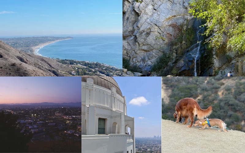
Best First Hike in LA: Mount Hollywood via Griffith Observatory
If you want one hike that screams “Los Angeles” without being a suffer-fest, Mount Hollywood from Griffith Observatory is hard to beat. You get:
- Views of the Hollywood Sign
- A front-row look at the Observatory itself
- Panorama over the whole basin—from Downtown to the ocean on a clear day
Most people start near the Observatory and follow one of the dirt fire roads up. It’s not technical, but it is uphill, so expect to breathe a bit. Distance and elevation depend on the route you take, but budget 1.5–2.5 hours with photo stops.
Style note: This is where “city meets trail” really shows. On any given day you’ll see everything from running shorts and trail shoes to fashion sneakers, big sunglasses, and a tote bag. I still recommend real traction underfoot and breathable technical fabrics—climbing out of Griffith’s canyons in a heavy cotton hoodie is not fun once the sun hits you.
Best Hike Near Hollywood / West Hollywood: Runyon Canyon
Is Runyon Canyon overhyped? Yes. Is it still useful? Also yes.
If you’re staying in Hollywood or West Hollywood and you don’t have a car, Runyon is one of the easiest trailheads to reach. You get:
- Short, steep loops (or a more gentle fire road)
- Big views of the city and Hollywood Hills
- Serious people-watching—this is as much a social scene as a hike
If you only have an hour between meetings, or you want a quick sweat before dinner, it does the job. Just don’t come here expecting solitude.
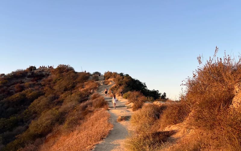
Best Quick Ocean-View Hike: Los Liones (with Optional Parker Mesa)
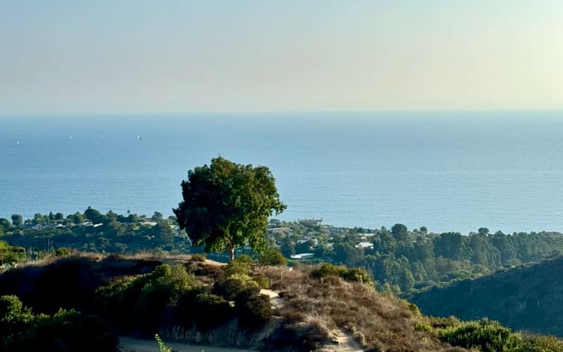
Head to Pacific Palisades and you’re in the Santa Monica Mountains, with the ocean almost always in the corner of your eye.
- The Los Liones trail starts in a leafy canyon and climbs steadily to a lookout bench with sweeping views over the Pacific and Santa Monica.
- If you’ve got more time and energy, continue along the ridge to Parker Mesa Overlook for a bigger day and an even wider panorama.
This is one of those hikes where the payoff feels disproportionate to the effort. On a clear winter day, you can see down the coast and sometimes even out to the Channel Islands.
Best Family-Friendly Starter: Eaton Canyon
If you’re okay with a short drive to Pasadena, Eaton Canyon is a classic beginner-friendly hike with a real “wow” moment: a waterfall at the end when water is flowing. The trail is:
- Relatively flat for most of the way
- Easy to follow
- Full of kids, dogs, and multi-generational families on weekends
It’s a great first introduction to SoCal canyon hiking, but note: in dry periods, the waterfall shrinks, and after storms, some stream crossings can be a bit messy. Check recent reports before you go.
Best Hikes in LA by Area
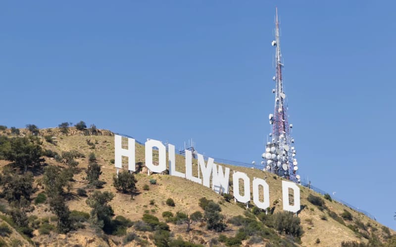
Griffith Park & the Hollywood Sign Area
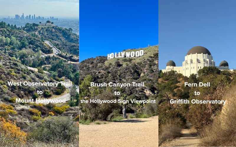
Griffith Park is one of the largest urban parks in the US, and there are enough trails here to keep you busy for a long time.
Good options:
-
West Observatory Trail to Mount Hollywood – A clean way to link the Observatory with the summit. Great for sunrise or sunset.
-
Brush Canyon Trail to the Hollywood Sign Viewpoint – More of a sustained climb with closer views of the Sign. This is a viewpoint, not a “stand on the letters” situation—respect the closures and fences.
- Fern Dell to Griffith Observatory – Shorter, greener, and good if you’re short on time but still want to feel like you walked to the Observatory rather than just parked on top.
If you’re unsure where to start, Mount Hollywood is the most “all-rounder” hike: it feels like a proper outing but doesn’t demand full mountain fitness.
Hollywood & Central LA
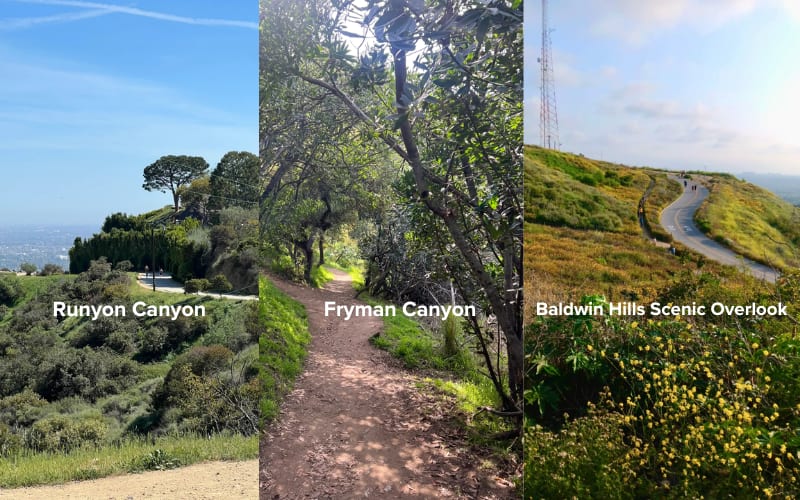
Right in the middle of the city, you’ve got a few hills that are basically outdoor gyms.
-
Runyon Canyon – Short, steep, crowded, very “Hollywood.”
-
Fryman Canyon – Slightly more low-key, popular with locals, loop options.
- Baldwin Hills Scenic Overlook – A short, stair-filled grind with a big view at the top. Great if you just want to blast your legs in 30–45 minutes.
These are the spots where technical menswear really shines: you might get lunch in West Hollywood, walk over to Runyon, and then head straight to a coffee meeting afterwards. A breathable stretch pant and a lightweight tech tee or overshirt doesn’t look out of place in either setting.
West Side & Santa Monica Mountains
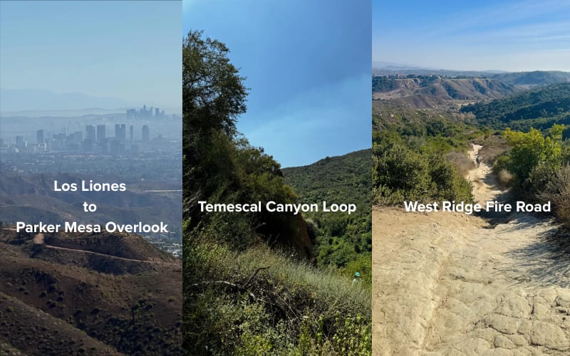
If you’re based in Santa Monica, Venice, or the Palisades, the Santa Monica Mountains are your backyard.
Some staples:
-
Los Liones to Parker Mesa Overlook – Mentioned above; long ridge views over the ocean.
-
Temescal Canyon Loop – A solid loop with a canyon, ridgeline, and (seasonal) waterfall/stream.
- Westridge Fire Road – Wide, dog-friendly, very popular with trail runners and mountain bikers.
These hikes are exposed. Even on cooler days, UV is strong, and there isn’t much shade once you’re on the ridge. This is where light, quick-drying fabrics and a cap are worth their weight in gold.
Malibu & Coastal Canyons
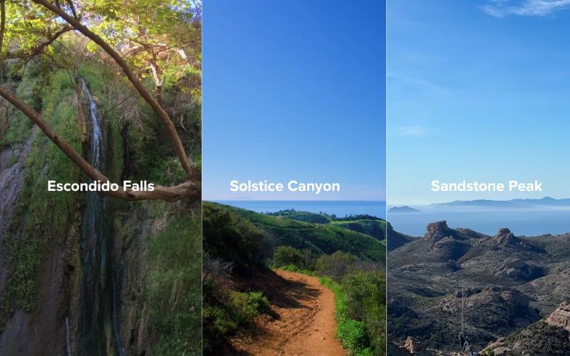
Malibu is where the “LA fantasy” becomes reality: deep canyons, blue water, and occasionally a celebrity walking their dog in head-to-toe cashmere on a dirt trail.
Great picks here:
-
Escondido Falls – One of the more famous waterfall hikes near the coast. Shorter and moderate, but very dependent on rainfall for a proper show
-
Solstice Canyon – A mellow loop with ruins, shade, and some water features after rain.
- Sandstone Peak (via Mishe Mokwa) – The highest point in the Santa Monica Mountains and one of the best bang-for-your-buck views near LA.
For Malibu hikes, I like a light base layer plus a packable shell. It’s common to start cool and coastal, then bake on the switchbacks once the sun is high.
San Gabriel Mountains: Real Mountain Days Near LA
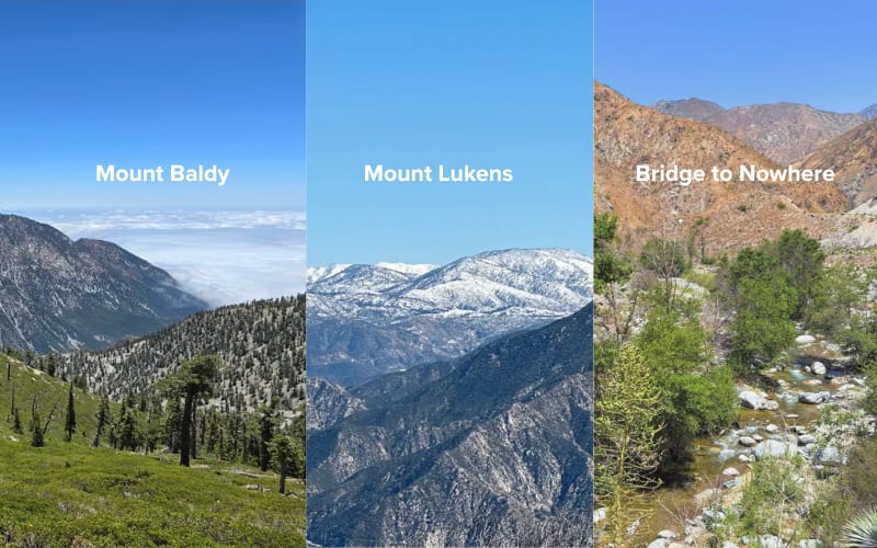
If you want to feel like you’ve left the city without driving for half a day, the San Gabriel Mountains are your spot. Within about an hour of central LA, you can be at a trailhead that feels like another world.
Some standouts:
-
Mount Baldy (Mount San Antonio) – Classic SoCal peak. Long, steep, and absolutely not a beginner hike, but the summit views are worth the effort on a clear day.
-
Mount Lukens – A big climb and less famous than Baldy, but still a serious workout with views back over the city.
- Bridge to Nowhere & other canyon routes – More adventure-style days with river crossings and interesting terrain.
For these, you’re in “proper mountain” territory: check weather, carry enough layers, pay attention to snow/ice conditions in winter and early spring, and treat them with more respect than a casual city hike.
Best Hikes in LA by Difficulty
Everyone’s fitness and experience level is different. The labels “easy” and “hard” are always a bit subjective, but here’s a rough breakdown.
Best Hikes in LA for Beginners
If you’re new to hiking or just want something gentle:
-
Eaton Canyon – Waterfall (in season), wide path, social vibe.
-
Solstice Canyon – Shaded canyon walk with ruins and a small waterfall when there’s water.
- Griffith Park: Fern Dell to the Observatory – Short but scenic; you can always extend further into the park.
Tips for easy hikes:
- Don’t let “easy” fool you—heat and dehydration still apply.
- Stop before you feel wrecked; the idea is to leave wanting a bit more, not to swear off hiking forever.
Moderate Hikes in LA
For regular walkers or gym-goers who want a bit of a challenge:
- Mount Hollywood via longer routes in Griffith Park
- Los Liones to the first main viewpoint (or Parker Mesa if you’re feeling strong)
-
Temescal Canyon Loop
These are often 2–4 hours, with some climbing but nothing technical. Perfect weekend morning material.
Best Mountain Hikes Near Los Angeles (Challenging Hikes)
If your idea of a good time is a long day, sore quads, and a summit photo, LA actually has some surprisingly legit options.
You’re looking at routes like:
-
Mount Baldy – Big elevation gain, exposed sections, and potentially snow/ice in colder months.
-
Strawberry Peak – A steep, rugged peak with classic San Gabriel views.
- Mount Baden-Powell & nearby peaks off the Angeles Crest – Especially now that long-closed highway sections have reopened, access has improved for some of these trailheads.
These aren’t “I just bought new sneakers, let’s try a hike” outings. Bring real footwear, enough food and water, and layers—the weather swings fast in the higher mountains.
For these challenging routes, it’s important to be honest about:
- Fitness level: you should be comfortable with several hours of steady climbing
- Time: plan for most of a day including the drive
- Preparation: extra water, real hiking shoes, and an eye on weather and daylight
Best Hikes in LA by Experience Type
Best Ocean-View Hikes in Los Angeles
If your non-negotiable is seeing the Pacific:
-
Los Liones → Parker Mesa – Consistent ocean views once you hit the ridge.
-
Temescal Ridge – When the marine layer cooperates, the coastline looks unreal from up here.
- Sandstone Peak – Mountain feel with ocean views in the distance.
These are perfect for testing fabrics: it might be cool and cloudy at the start and blazing by the time you’re halfway up. Breathable, quick-drying pieces matter more than any particular “outdoor aesthetic.”
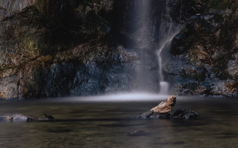
Best Hikes in Los Angeles With Waterfalls
Let’s be honest: LA’s waterfalls are not exactly Iceland-level, and they’re very seasonal. But when the rain has been good, these can feel like magic.
Good bets (depending on conditions):
-
Eaton Canyon Falls – Easy to moderate, popular, great intro.
-
Escondido Falls – Malibu classic, more impressive after steady rain.
- Sturtevant Falls & Switzer Falls – In the San Gabriels, with more of a forest feel.
A few honest notes:
- Check recent reports before you go; some falls are dry for large parts of the year or affected by closures.
- Expect crowds on weekends—it’s not a secret.
- Rocks near waterfalls are slick; this is not the place for fashion sneakers with flat soles.
Best Sunset & City-View Hikes
If your goal is to watch the city light up:
-
Griffith Observatory → Mount Hollywood – Classic sunset into city-lights combo.
-
Runyon Canyon ridge lines – Short and steep; you’ll share it with half of LA, but the view is real.
- Baldwin Hills Scenic Overlook – Stairs plus an overlook that feels like the city is on a plate in front of you.
Plan to start early enough that you’re not coming down in full darkness if you’re unfamiliar with the trail. Headlamp > phone flashlight.
Best Hikes in LA for a Date
A good date hike is not a death march. Think:
- 1–2 hours total
- Enough effort to feel like you did something, but still easy to talk
- Somewhere nearby to grab coffee or food afterwards
Solid choices:
-
Solstice Canyon – Gentle, shaded, with ruins to explore.
-
Los Liones to the first lookout – Slightly more effort, big views for a shared “we did it” moment.
-
Griffith Observatory area loops – You can add the museum and a drink afterwards.
Skip the super narrow or sketchy stuff; nobody falls in love walking along a crumbly, exposed edge.
Dog-Friendly & Family-Friendly Options
You’ll find dogs on almost every LA trail, but leash rules vary. A few generally dog-friendly picks:
For families with younger kids:
- Eaton Canyon (turn back before the waterfall if the crossings look too wild)
- Short loops around Griffith Park’s lower trails
- Solstice Canyon
Think wide paths, low drop-offs, and an easy escape back to the car if energy crashes.
When to Hike in LA
Seasons
-
Summer: Start very early or go late. Stay away from long exposed climbs in the middle of the day.
-
Fall:Probably the best hiking weather: clear, cooler, and stable.
-
Winter: Great for crisp city views and cooler temps on local hills. Check conditions on mountain hikes—snow and ice are real up high.
- Spring: Your best shot at waterfalls and wildflowers, especially after a wet winter.
Time of Day
-
Early morning: fewer people, cooler, softer light.
-
Late afternoon into sunset: beautiful, but plan your timing and bring a light if there’s any chance you’ll finish in the dark.
- Midday in summer: honestly, unless it’s a very short, shady trail, I’d avoid it.
Practical Stuff: What to Wear, Safety, and Parking

LA hiking is tricky because the weather swings more by location and time of day than by month. You can be warm in a T-shirt in Griffith Park and shivering in the wind on Mount Baldy the same week. The goal isn’t to dress “outdoorsy” – it’s to build a small system of layers that works from city sidewalk to exposed ridgeline.
Warm Days & Everyday Trails
For most city and canyon hikes (Runyon, Griffith, Temescal on a mild day), a light, breathable shell over a tee is usually enough.
Our Graphene Lightweight Jacket is built exactly for that zone: it’s thin, packs easily into a bag, but the graphene back panel quietly holds onto just enough warmth when the breeze picks up. It looks clean enough for coffee after the trail, and you’re not sweating through a heavy puffer on the climb.
If you run warm or know you’ll be moving fast, swapping to the Graphene Vest keeps your core comfortable without overcooking your arms. It layers over a long-sleeve or sweatshirt, adds a surprising amount of warmth for the weight, and still feels like something you’d wear around the city, not just on a trail.
Cool Mornings, Windy Ridges & Shoulder Season
Sunrise starts in the Santa Monica Mountains or late-fall walks in the canyons are where a true “do-it-all” jacket earns its place.
Alpargali CoreShell is designed for that: softshell comfort, enough insulation to take the edge off cold air, and weather protection if the wind picks up or there’s a bit of drizzle. It’s the kind of piece you put on in a cold parking lot and don’t think about again – it stretches when you move, vents heat on the climb, and still looks sharp back in town.
When the forecast looks unstable – possible showers, cooler temps, lots of time outside – the Alpargali Men’s All-Weather Outdoor Jacket becomes the safer choice. It’s a proper shell you can trust for rain, wind, and long days out, but it’s cut and finished so it doesn’t feel out of place on a flight or at a café. The pockets are overkill in a good way: snacks, phone, cards, small camera, boarding pass – everything has a home, which is very handy if you like to travel light.
Real Mountain Days & Cold Conditions
LA does have real winter days – they just tend to happen above 2,000–3,000 meters instead of on the beach. If you’re heading up to Baldy, into the higher San Gabriels, or planning a pre-dawn start in cold, dry air, that’s when a serious insulated layer makes sense. Our Alpargali Aerogel Graphene Puffer Jacket is built for exactly those conditions: very warm for its weight, wind-blocking, and comfortable when you’re standing still on a summit taking in the view.
On big days we usually pair it with a lighter piece underneath (the Graphene Vest or Graphene Lightweight Jacket, depending on how cold it is). That way you can hike in the lighter layer, then throw the puffer on at rest stops or at the top. It keeps your system flexible: you’re not stuck sweating in a heavy jacket on the climb just because it’s freezing at the trailhead.
The short version:
- Graphene Lightweight Jacket / Graphene Vest → most LA city & canyon hikes, almost year-round.
- CoreShell → cool, windy, or shoulder-season days when you want one jacket that does almost everything.
- Men’s All-Weather Outdoor Jacket → when weather is unpredictable, you’re out all day, or you’re traveling and want one shell for planes + trails.
- Aerogel Graphene Puffer Jacket → real cold, higher mountains, sunrise missions, and any day you expect to be standing around in low temperatures.
Safety
- Carry more water than you think. For most moderate LA hikes, 1.5–2 liters per person is a good baseline; more for longer, hotter, or steeper days.
- Don’t underestimate heat. If you start feeling dizzy, chilled, or weirdly “off” on a hot day, that’s a red flag.
- Stay on marked trails; it’s easy to get turned around in canyons and unofficial shortcuts erode the landscape.
Parking & Access
- Popular trailheads (Runyon, Griffith, Eaton Canyon, Temescal) fill up early on weekends.
- Some areas have permit or pass requirements—always check signage and official sites rather than assuming.
How to Choose Your First (or Next) LA Hike
If you’re staring at this list feeling overwhelmed, here’s a simple way to decide:
- New to hiking, or haven’t walked more than 30 minutes in a while?
- Start with Eaton Canyon, Solstice Canyon, or a short loop in Griffith Park.
- Comfortable walking a few hours and want views?
- Try Mount Hollywood, Temescal Canyon Loop, or Los Liones to the main lookout.
- Looking for a challenge and already hiking regularly?
- Work up to Sandstone Peak or a big day in the San Gabriels, and aim for Mount Baldy when your legs (and logistics) are ready.
Use this hiking guide to choose a trail, mark a day, and give yourself a few hours off the grid. When you’re ready to think about a small, reliable kit for those LA days that go from meetings to trailheads, Alpargali is a good place to start.


