


Table of Contents
- The 25 Best Hikes in Arizona
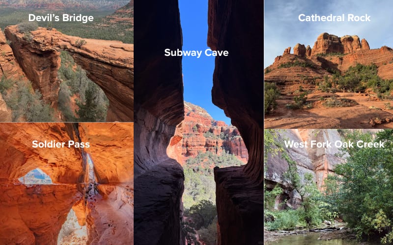
- 1. Devil’s Bridge
- 2. Cathedral Rock
- 3. Boynton Canyon + Subway Cave
- 4. Soldier Pass & Seven Sacred Pools
- 5. West Fork Oak Creek
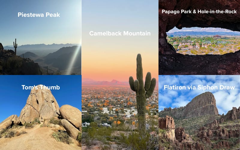
- 6. Camelback Mountain (Echo Canyon or Cholla)
- 7. Piestewa Peak
- 8. Papago Park & Hole-in-the-Rock
- 9. Tom's Thumb
- 10. Flatiron via Siphon Draw
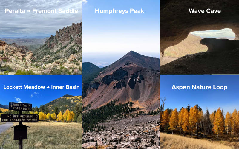
- 11. Wave Cave
- 12. Peralta → Fremont Saddle
- 13. Humphreys Peak
- 14. Lockett Meadow → Inner Basin
- 15. Aspen Nature Loop
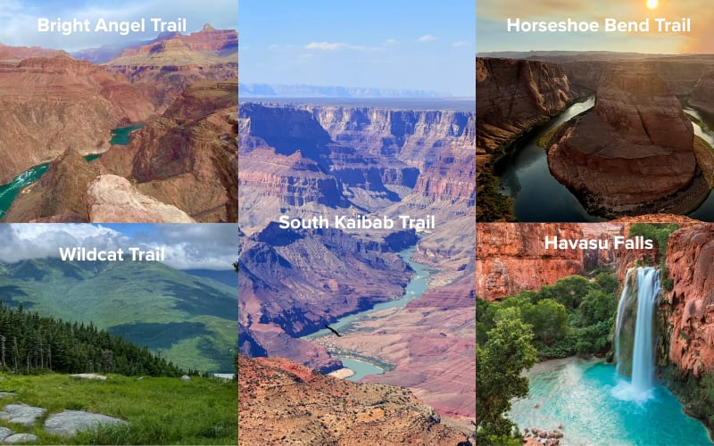
- 16. South Kaibab Trail (to Ooh-Aah Point / Cedar Ridge)
- 17. Bright Angel Trail
- 18. Horseshoe Bend Trail
- 19. Wildcat Trail
- 20. Havasu Falls
- 21. Water Wheel Falls
- 22. Fossil Springs
- 23. Gateway Loop Trail
- 24. Seven Falls
- 25. Romero Canyon Falls
- Quick Trail Finder: Which Trail Is the Best Hike in Arizona for You
- Waterfall Hikes in Arizona
- Best Hikes Near Phoenix with Water
- Best Hikes in Arizona with Water
- Best Hikes in Arizona in December
- Best Day Hikes Near Phoenix
- Best Day Hikes in Arizona
- Best Hikes in Northern Arizona
- Best Hikes in Arizona Mountains
- Best Hikes in Sedona
- Hike Arizona Safety Guide
- Best Seasons to Hike in Arizona
- Common Arizona Climate Challenges
- What to Wear: Layering for Arizona
- Permits, Parking & Shuttle Essentials
- Sample Itineraries
- Let Alpargali guide you through Arizona
- FAQ
Arizona is a hiker’s dream, offering diverse landscapes — from red rock deserts to towering mountains and deep canyons. The state’s variety makes it a top hiking destination, whether you're in the desert or exploring lush highlands.
In this guide, we’ll cover the top hikes in Arizona, from easy walks to challenging treks, and provide tips on how to layer your gear for both city and trail. Whether you’re a beginner or a seasoned hiker, Arizona has something for everyone.
Related Reading:
- Best hikes in San Diego
- Best hikes in Oregon
- Yellowstone hikes
- Best hikes in LA
- Hiking trails in Austin
- Best hikes in Michigan
The 25 Best Hikes in Arizona
We've handpicked 20 of the best routes, ranging from desert landscapes to majestic mountains and breathtaking canyons. Whether you're a hiking beginner or a seasoned pro, there's a route for you.
1. Devil’s Bridge
- Distance: 4.0 miles (6.4 km)
- Elevation Gain: 420 ft (128 m)
- Time Required: 2–3 hours
- Address: Dry Creek Rd, Sedona, AZ 86336, US
- Google Map: https://maps.app.goo.gl/p6ZM2bjopK9Ns6Nd7
A must-do hike in Sedona, this trail takes you to a stunning natural rock bridge with expansive views of the red rock landscape. The final stretch involves a bit of scrambling, but the views are worth every step.
2. Cathedral Rock
- Distance: 1.2 miles (1.9 km)
- Elevation Gain: 750 ft (229 m)
- Time Required: 1–2 hours
- Address: 2800 W. State Route 89A, Sedona, AZ 86336, US
- Google Map: https://maps.app.goo.gl/dS3T63UNZPJQctq3A
One of Sedona’s most iconic hikes, Cathedral Rock offers a short but challenging scramble. The views from the top are unbeatable, especially at sunrise or sunset, but be prepared for a steep, rocky climb.
3. Boynton Canyon + Subway Cave
- Distance: 6.6 miles (10.6 km)
- Elevation Gain: 700 ft (213 m)
- Time Required: 3–4 hours
- Address: 220 Boynton Canyon Rd, Sedona, AZ 86336, US
- Google Map: https://maps.app.goo.gl/C3RV7eXRz4DFv9zr9
This 6.6-mile trail takes you through the scenic Boynton Canyon, with the optional detour to Subway Cave. The cave offers a unique spot for photos, and the entire hike is filled with red rock vistas and desert flora.
4. Soldier Pass & Seven Sacred Pools
- Distance: 5.7 miles (9.1 km)
- Elevation Gain: 1,000 ft (305 m)
- Time Required: 3–4 hours
- Address: Forest Service 9904 Rd, Sedona, AZ 86336
- Google Map: https://maps.app.goo.gl/RoqCVf7ZC6DN9ME68
A beautiful hike that combines red rock scenery with historic sites. The Seven Sacred Pools are a series of small, natural pools surrounded by rocks, with a bit of scrambling required to reach the area.
5. West Fork Oak Creek
- Distance: 6.5 miles (10.5 km)
- Elevation Gain: 600 ft (183 m)
- Time Required: 3–4 hours
- Address: W Fork Trail, Sedona, AZ 86336
- Google Map: https://maps.app.goo.gl/X7sNWtGLQKYez8oN6
A more relaxed hike compared to others in Sedona, this 6.5-mile trail winds through a lush canyon with creek crossings and towering canyon walls. It's particularly beautiful in the fall when the trees change color.
6. Camelback Mountain (Echo Canyon or Cholla)
- Distance: 2.3 miles (3.7 km)
- Elevation Gain: 1,134 ft (345 m)
- Time Required: 2–3 hours
- Address: Phoenix, AZ 85018
- Google Map: https://maps.app.goo.gl/8oeWGtJmBJGhn2dH6
Both the Echo Canyon and Cholla Trails are popular and challenging hikes in Phoenix. Echo Canyon is steeper and involves some scrambling, but both trails reward you with panoramic views of the city.
7. Piestewa Peak
- Distance: 2.1 miles (3.4 km)
- Elevation Gain: 1,148 ft (350 m)
- Time Required: 2 hours
- Address: 2701 Piestewa Peak Dr, Phoenix, AZ 85016
- Google Map: https://maps.app.goo.gl/ybwEQ6kWnr1WiH5Q6
A 2.1-mile hike with an elevation gain of 1,148 feet, this popular Phoenix hike is known for its steep ascent. The summit offers 360-degree views of the city and surrounding mountains. It’s a great workout and a favorite for locals.
8. Papago Park & Hole-in-the-Rock
- Distance: 1.0 miles (1.6 km)
- Elevation Gain: 200 ft (61 m)
- Time Required: 30–45 minutes
- Address: 625 N Galvin Pkwy, Phoenix, AZ 85008, US
- Google Map: https://maps.app.goo.gl/TZmRBkQGqakdwQZN7
This is a quick, family-friendly hike in Phoenix, perfect for an afternoon outing. The Hole-in-the-Rock formation provides a unique photo opportunity with views over the surrounding desert landscape.
9. Tom's Thumb
- Distance: 4.2 miles (6.8 km)
- Elevation Gain: 1,086 ft (331 m)
- Time Required: 3 hours
- Address: McDowell Sonoran Preserve, Scottsdale, AZ (Trailhead: 22606 N Scottsdale Rd)
- Google Map: https://maps.app.goo.gl/QvkVhFK6sQJ6CXvP8
A 4.2-mile trail in the McDowell Sonoran Preserve, Tom's Thumb offers a bit of everything: great views, moderate difficulty, and the iconic thumb-shaped rock formation at the summit. The trail’s moderate-to-hard rating makes it a solid challenge for hikers.
10. Flatiron via Siphon Draw
- Distance: 5.5 miles (8.9 km)
- Elevation Gain: 2,582 ft (787 m)
- Time Required: 4–5 hours
- Address: Lost Dutchman State Park, 6109 N Apache Trl, Apache Junction, AZ 85119, US
- Google Map: https://maps.app.goo.gl/CC76v4ycAQyaaAFb7
This challenging hike is for experienced hikers ready to tackle a steep ascent to the iconic Flatiron peak. The 5.5-mile trail involves scrambling, but the views at the summit are truly breathtaking.
11. Wave Cave
- Distance: 3.0 miles (4.8 km)
- Elevation Gain: 890 ft (271 m)
- Time Required: 2–3 hours
- Address: CJ2F+M4, Gold Canyon, AZ 85118
- Google Map: https://maps.app.goo.gl/fRCEwafQZS8wq5x67
A beautiful cave hike in the Superstition Mountains, the Wave Cave is an excellent spot for both beginner and moderate hikers. The trail offers a mix of desert views and a unique cave experience at the top.
12. Peralta → Fremont Saddle
- Distance: 4.7 miles (7.6 km)
- Elevation Gain: 1,313 ft (400 m)
- Time Required: 3 hours
- Address: Peralta Trailhead, Peralta Rd, Apache Junction, AZ 85119, US
- Google Map: https://maps.app.goo.gl/Wmtgngxqi337hLed8
This 4.7-mile trail offers a scenic route to Fremont Saddle with views of the iconic Weaver’s Needle. It’s a challenging yet rewarding hike that is best done early to avoid the desert heat.
13. Humphreys Peak
- Distance: 9.5 miles (15.3 km)
- Elevation Gain: 3,346 ft (1,019 m)
- Time Required: 6–8 hours
- Address: Humphreys Summit Trail, Flagstaff, AZ 86001
- Google Map: https://maps.app.goo.gl/mAAWQMsHv1SCSKNS6
At 12,633 feet, Humphreys Peak is Arizona’s highest point. The 9.5-mile trail is a strenuous hike that takes you through alpine meadows and forests to the summit, offering spectacular views on a clear day.
14. Lockett Meadow → Inner Basin
- Distance: 5.4 miles (8.7 km)
- Elevation Gain: 1,202 ft (366 m)
- Time Required: 3–4 hours
- Address: Unnamed Road, Flagstaff, AZ 86001
- Google Map: https://maps.app.goo.gl/nnuH6E8T8Mv4NJV58
This 5.4-mile trail in Flagstaff takes you through a forest of aspens, leading you to the beautiful Inner Basin. It’s a perfect hike for fall when the trees are turning vibrant colors.
15. Aspen Nature Loop
- Distance: 2.32 miles (3.7 km)
- Elevation Gain: 297 ft (91 m)
- Time Required: 1–1.5 hours
- Address: Arizona 86001, Humphrey's Peak Trail, Flagstaff, AZ 86001
- Google Map: https://maps.app.goo.gl/ThbTEVHYywvv1hsW6
A short, easy loop trail that’s perfect for families or beginner hikers. Located near Arizona Snowbowl, this 2.3-mile trail offers beautiful views of the high-altitude aspen trees, especially stunning in autumn.
16. South Kaibab Trail (to Ooh-Aah Point / Cedar Ridge)
- Distance: 1.8–4.4 miles (2.9–7.1 km)
- Elevation Gain: 1,440 ft (439 m)
- Time Required: 1.5–5 hours
- Address: South Kaibab Trailhead, Grand Canyon National Park, AZ 86023, US
- Google Map: https://maps.app.goo.gl/DrFmKngsxGC4tgFDA
The South Kaibab Trail offers some of the best views of the Grand Canyon, especially at sunrise. The Ooh-Aah Point is a quick, easy hike, while heading further to Cedar Ridge is more challenging but rewarding with panoramic views.
17. Bright Angel Trail
- Distance: 9.0–16.0 miles (14.5–25.7 km)
- Elevation Gain: 4,380 ft (1,334 m)
- Time Required: 5–10 hours
- Address: Bright Angel Trailhead, Grand Canyon Village, AZ 86023, US
- Google Map: https://maps.app.goo.gl/jTmf7eMF1QMrAYDE6
One of the most famous trails in the Grand Canyon, the Bright Angel Trail descends deep into the canyon. It’s a long hike, but the reward is experiencing the canyon from the inside, with rest stops along the way.
18. Horseshoe Bend Trail
- Distance: 1.5 miles (2.4 km)
- Elevation Gain: 200 ft (61 m)
- Time Required: 1 hour
- Address: US-89, Page, AZ 86040
- Google Map: https://maps.app.goo.gl/u1ouPoNXUJ4WprgU7
A quick, easy trail that leads you to one of Arizona’s most photographed landmarks — the stunning Horseshoe Bend. This short 1.5-mile walk offers incredible views of the Colorado River from above.
19. Wildcat Trail
- Distance: 3.8 miles (6.1 km)
- Elevation Gain: 400 ft (122 m)
- Time Required: 2–3 hours
- Address: Oljato-Monument Valley, UT 84536
- Google Map: https://maps.app.goo.gl/Dra8rLUcTefCKXmKA
A 3.8-mile loop in the iconic Monument Valley, the Wildcat Trail takes you close to the towering rock formations. It’s an easy-to-moderate trail with wide-open desert views that feel like stepping into a Western film.
20. Havasu Falls
- Distance: 10.0 miles (16.1 km) one way
- Elevation Gain: 2,400 ft (732 m)
- Time Required: 6–8 hours one way
- Address: Havasupai Reservation, Supai, AZ 86435, US
- Google Map: https://maps.app.goo.gl/s1naenDoMUNHdgyo6
A stunning, multi-day hike to one of the most famous waterfalls in the country. The turquoise waters of Havasu Falls are worth the long trek, but permits are required and can be difficult to obtain.
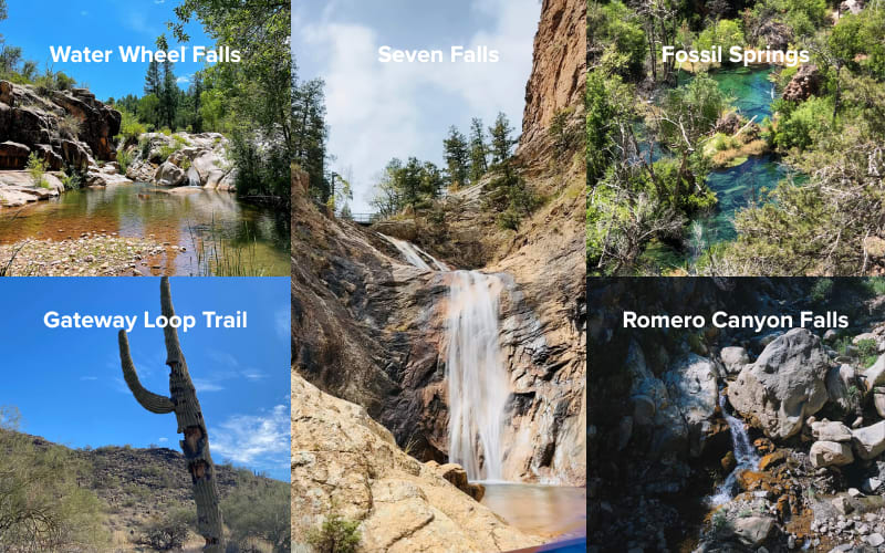
21. Water Wheel Falls
- Distance: 1.6 miles (2.6 km)
- Elevation Gain: 150 ft (46 m)
- Time Required: 1–1.5 hours
- Address: Water Wheel Falls, Payson, AZ 85541, US
- Google Map: https://maps.app.goo.gl/h2j2zkxBbvq7anM3A
Located near Payson, Water Wheel Falls is a refreshing hike that leads to a series of small waterfalls along Ellison Creek. It’s a popular spot to cool off, especially in the warmer months.
22. Fossil Springs
- Distance: 8.4 miles (13.5 km)
- Elevation Gain: 1,522 ft (464 m)
- Time Required: 4–5 hours
- Address: Fossil Springs Rd, Strawberry, AZ 85544, US
- Google Map: https://maps.app.goo.gl/qaf5HC3PGdA7hoS89
A challenging 8.4-mile hike that leads to the beautiful Fossil Springs, a clear, spring-fed swimming hole. The hike requires a steep descent and a tough climb back, but it’s worth it for the stunning waterfall.
23. Gateway Loop Trail
- Distance: 4.3 miles (6.9 km)
- Elevation Gain: 622 ft (190 m)
- Time Required: 2–3 hours
- Address: Gateway Trailhead, Scottsdale, AZ 85262, US
- Google Map: https://maps.app.goo.gl/SrPaYgqtZV2GHsmE8
A favorite for beginners and those looking for a moderate challenge, Gateway Loop Trail offers beautiful desert scenery and an easy-to-follow path. It’s a great introductory hike in the Scottsdale area.
24. Seven Falls
- Distance: 7.0 miles (11.3 km)
- Elevation Gain: 961 ft (293 m)
- Time Required: 3–4 hours
- Address: 5700 N Sabino Canyon Rd, Tucson, AZ 85750
- Google Map: https://maps.app.goo.gl/zkbY49oA8cynBhdeA
Located in Sabino Canyon, Seven Falls is a beautiful hike that takes you to a series of cascading waterfalls. The trail involves creek crossings, making it a great option for a cool hike during the summer months.
25. Romero Canyon Falls
- Distance: 6.1 miles (9.8 km)
- Elevation Gain: 1,318 ft (402 m)
- Time Required: 3–4 hours
- Address: Romero Cyn Trl, Tucson, AZ 85737
- Google Map: https://maps.app.goo.gl/7tJJFAvdw83d4mSW6
This hike in Catalina State Park takes you through a scenic canyon to a series of seasonal waterfalls. The trail can be steep in places, but the views and waterfall make it worth the effort.
Quick Trail Finder: Which Trail Is the Best Hike in Arizona for You
Arizona boasts a plethora of hiking trails, making it easy to feel overwhelmed. Therefore, we've meticulously crafted this quick trail finder to help you discover your ideal route based on your preferences, such as difficulty, theme, location, or season.
| Trail Name | Location | Difficulty | Theme | Best Season |
| Lockett Meadow → Inner Basin | Flagstaff | Moderate | Forest, Wildflowers, Fall Colors | Winter, Summer |
| Humphreys Peak | Flagstaff | Hard | Summit, Forest | Winter, Summer |
| Aspen Nature Loop | Flagstaff | Easy | Forest, Fall Colors | Winter, Fall |
| Havasu Falls | Havasupai Reservation | Challenging (Permit Required) | Waterfall & Water | Spring, Fall |
| Wildcat Trail | Monument Valley | Moderate | Canyon | Fall, Winter, Spring |
| Horseshoe Bend Trail | Page | Easy | Canyon Views | Year-Round |
| Papago Park & Hole-in-the-Rock | Phoenix | Easy | Family-Friendly, Urban Hikes | Fall, Winter, Spring |
| Camelback Mountain (Echo Canyon or Cholla) | Phoenix | Hard | Urban Hard Core | Fall, Winter, Spring |
| Piestewa Peak | Phoenix | Hard | Urban Hard Core | Fall, Winter, Spring |
| Water Wheel Falls | Payson | Easy to Moderate | Waterfall & Water | Spring, Summer |
| Fossil Springs | Strawberry | Moderate | Waterfall & Water | Late Spring, Summer |
| Gateway Loop Trail | Scottsdale | Moderate | Scenic Views, Urban Hikes | Fall, Winter, Spring |
| Tom's Thumb | Scottsdale | Hard | Urban Hard Core | Spring |
| Cathedral Rock | Sedona | Hard | Red Rock | Spring, Fall |
| Devil's Bridge | Sedona | Moderate | Red Rock | Spring, Fall |
| Boynton Canyon + Subway Cave | Sedona | Moderate | Red Rock | Spring |
| Soldier Pass & Seven Sacred Pools | Sedona | Moderate | Red Rock | Fall |
| West Fork Oak Creek | Sedona | Easy | Red Rock, Waterfall & Water | Spring |
| Flatiron via Siphon Draw | Superstition Mountains | Hard | Summit Views | Fall, Winter, Spring |
| Wave Cave | Superstition Mountains | Moderate | Waterfall & Water | Spring, Fall |
| Peralta → Fremont Saddle | Superstition Mountains | Moderate | Canyon | Fall |
| Seven Falls | Tucson | Moderate | Waterfall & Water | Winter, Spring |
| Romero Canyon Falls | Catalina State Park | Moderate to Hard | Waterfall, Canyon | Winter, Spring |
| South Kaibab Trail (to Ooh-Aah Point / Cedar Ridge) | Grand Canyon | Moderate to Hard | Canyon | Spring |
| Bright Angel Trail | Grand Canyon | Hard | Canyon | Spring, Fall |
Waterfall Hikes in Arizona
-
Havasu Falls: Iconic turquoise waterfalls, challenging hike, permits required.
- Seven Falls: Seasonal waterfalls, great for a swim on hot days.
Best Hikes Near Phoenix with Water
-
West Fork Oak Creek: Creekside, shaded, with scenic canyon views.
- Water Wheel Falls: Short, family-friendly hike with a beautiful waterfall.
Best Hikes in Arizona with Water
-
Havasu Falls: Famous waterfalls with turquoise pools, permits needed.
- West Fork Oak Creek: Peaceful creekside hike, perfect for a cooling dip.
Best Hikes in Arizona in December
-
Bright Angel Trail: Mild temperatures, scenic views, great for winter hiking.
- Camelback Mountain: Popular for city views, challenging hike.
Best Day Hikes Near Phoenix
-
Piestewa Peak: 360-degree views of Phoenix, challenging but rewarding.
- Gateway Loop: Easy desert hike with beautiful mountain views.
Best Day Hikes in Arizona
-
Devil’s Bridge: Famous rock arch, stunning red rock scenery.
- South Kaibab Trail: Quick, scenic descent into the canyon with amazing views.
Best Hikes in Northern Arizona
-
Humphreys Peak: Arizona’s highest peak, great for experienced hikers.
- Lockett Meadow to Inner Basin: Gorgeous fall hike through aspen forests.
Best Hikes in Arizona Mountains
-
Flatiron via Siphon Draw: Steep, challenging, rewarding summit views.
- Humphreys Peak: A tough climb with stunning panoramic views.
Best Hikes in Sedona
-
Cathedral Rock: Short, steep scramble with breathtaking views.
- Boynton Canyon + Subway Cave: Canyon hike with a unique rock formation cave.
Hike Arizona Safety Guide

Exploring Arizona’s trails is incredibly rewarding, but the environment demands respect. From desert heat to high-elevation cold, staying safe often comes down to timing, awareness, and choosing the right layers.
Best Seasons to Hike in Arizona
November → April: Arizona’s golden hiking window
Temperatures are cooler, weather is more stable, and both desert and mountain trails are at their best. Most routes on this list are ideal during these months.
May → September: desert heat becomes dangerous
Phoenix and surrounding low-desert areas routinely exceed 100°F (38°C). Many trails—including Camelback and Piestewa—close once temperatures hit triple digits. If you hike in summer, head to Flagstaff、Payson、Grand Canyon North Rim and always start before sunrise.
Common Arizona Climate Challenges
- Extreme Heat & Very Low Humidity: Sweat evaporates quickly—you may not notice dehydration until it hits hard.
- Huge Day–Night Temperature Swings: High-elevation areas (Flagstaff, Inner Basin, Humphreys Peak) can drop below freezing even when Phoenix feels like summer.
- Little Shade & Intense UV Exposure: Long stretches without cover make sun protection non-negotiable.
- Winter Snow in High Elevation: Humphreys Peak, Inner Basin, and North Rim can have ice or snow well into spring.
What to Wear: Layering for Arizona
Hiking in Arizona demands smart layering to handle the desert heat, cool mornings, and unpredictable weather. Here’s how to layer effectively:
Base Layer: Moisture-Wicking & Breathable
A breathable base layer is essential for Arizona’s heat. The Nixcore Aerowool Nexus T-Shirt combines merino wool and TENCEL™ Modal for moisture-wicking, odor control, and temperature regulation—perfect for hot days or chilly mornings.
Mid Layer: Light Insulation
For cooler mornings in Sedona or Flagstaff, the Graphene Vest or Graphene Lightweight Jacket offers lightweight warmth and easy storage in your pack. Both feature graphene technology for effective insulation and comfort.
Outer Layer: Windproof & Water-Resistant
Arizona’s winds and dust require a durable outer layer. The Alpargali All-Weather Outdoor Jacket provides windproof, water-resistant protection—ideal for both desert hikes and city wear. It’s perfect for those unpredictable weather changes.
Bottoms: Durable & Stretchy
The Aether Mesa Flex Pants are abrasion-resistant, quick-drying, and flexible enough for rugged trails. They’re also stylish and comfortable for casual wear, making them perfect for both hiking and everyday use.
Cold Weather Protection
For alpine hikes in Flagstaff or Humphreys Peak, the Aerogel Graphene Puffer Jacket offers lightweight warmth, combining aerogel insulation and graphene technology to keep you warm without the bulk.
Accessories: Protection & Comfort
A sun hat or cap shields you from UV rays, while a neck gaiter keeps dust and sun at bay. Don’t forget moisture-wicking socks, sunglasses with UV protection, and light gloves for cooler mornings.
Permits, Parking & Shuttle Essentials
Arizona’s most popular hikes often come with rules or permits. Planning ahead saves both time and frustration.
- Sedona Shuttle System: Cathedral Rock、Soldier Pass、and others use shuttle-only access during peak season. Check schedules before you go.
- Havasupai Permit (Havasu Falls): Required for all visitors. Permits sell out quickly each year and are valid for multi-day trips only.
- The Wave (Coyote Buttes North) Lottery: Access is strictly controlled via advance and daily lotteries. Winning is rare—plan alternatives just in case.
- Grand Canyon Parking & Shuttles: South Kaibab Trailhead has no private parking—you must use the park shuttle. Bright Angel and South Rim viewpoints also have seasonal shuttle routes.
- Superstition Wilderness Notes: Trailheads like Peralta and Wave Cave involve dirt roads; conditions vary after storms. Arrive with extra water and avoid summer afternoons.
Sample Itineraries
3-Day Phoenix + Superstition Mountains: Piestewa Peak + Downtown Phoenix → Flatiron (or Wave Cave) → Tom’s Thumb + Old Town Scottsdale
4-Day Sedona + Grand Canyon Combo: Devil’s Bridge → Cathedral Rock (sunrise)+ West Fork → Grand Canyon South Kaibab → Bright Angel short section
7-Day Arizona Highlights: Phoenix → Superstitions → Sedona → Flagstaff → Grand Canyon → Page → Phoenix
Let Alpargali guide you through Arizona
Arizona is home to countless stunning hikes, each offering its own unique adventure. This hiking guide is designed to help you plan your trip, whether you're tackling iconic routes or seeking a more challenging summit.
Whether hiking, traveling, or just going about your day, Alpargali has the gear you need for all your adventures.
Ready to get started? Check out Alpargali outdoor gear and hit the trails in Arizona with comfort and style.
FAQ
What is the most scenic hike in Arizona?
Devil’s Bridge and the South Kaibab Trail at the Grand Canyon are often regarded as some of the most breathtaking, with expansive views and stunning landscapes.
What is the famous Arizona Trail?
The Arizona Trail is a long-distance hiking trail that spans the entire state from Mexico to Utah. It covers more than 800 miles and offers hikers a chance to experience a wide variety of Arizona’s natural beauty, from desert to mountains.
What is the most famous hike in Phoenix?
The most famous hike in Phoenix is Camelback Mountain via the Echo Canyon Trail, offering challenging terrain and incredible city views from the summit.
Which of the 7 wonders of the world is located in Arizona?
The Grand Canyon is one of the Seven Natural Wonders of the World, renowned for its immense size and stunning geological formations.
What is the prettiest part of Arizona?
Sedona is often considered the most beautiful part of Arizona, with its stunning red rock formations, lush canyons, and vibrant desert landscapes. The area offers incredible hiking, photography, and outdoor activities.


